There are two different ways you can get to the trail head on VA 620. We took the short way last year with Knitting Bull which required crossing a private bridge. This time we took the long way down a narrow winding road through an area which had some very run down houses and a couple of incredibly nice houses. We would not recommend the long way during bad weather.
We parked Gran’s truck at the very small parking area on VA 620. The temperature at the start of the hike was 28 degrees and it was not as windy as yesterday.
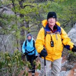
After we passed the Scout Trail, the trail got rocky and we had fun scrambling up the rocks. It was partly cloudy and then the snow flurries started.
Once we reached Rawies Rest, a knifes edge rocky rim, we had to climb up some really big boulders and pick our way around icy sections. Dirigo had more opportunities to practice her MovNat moves.
We came down into Lost Spectacles Gap with a very big camp site and a side trail that came from the Dragon’s Tooth parking area. The really fun stuff was ahead of us, and we had some side walls and narrow ledges to climb up and re-bar rung ladders to scale, but it was so much fun.
Once we reached the top of Cove Mountain, it got really windy. We took the side trail 0.2 miles to see Dragon’s Tooth and took several pictures with the snow surrounding the beautiful rock sculpture.
We met a male hiker who stayed at the Pickle Branch shelter. He looked very very cold and was hiking to his car at the Dragon’s Tooth parking lot.
We walked the ridge line for a long time and there was no protection from the wind. We all put on extra layers to stay warm and just kept moving. Our fingers were cold and we could not stay warm.
Once again Gran found a good lunch spot in the sunshine. We all hunkered down next to logs and kept low to stay out of the wind. It didn’t take long for our bodies to get get cold again.
The descent into VA 620 seemed to take forever! Fortunately, the descent was gentle and we eventually got some relief from the wind when we went to the other side of the mountain. The hike takes a circle around the mountain on the ridge line so you get a great view looking back from where we had just come from.
We decided to pass on the Pickle Branch Shelter since it was 1/3 of a mile off of the trail. As we approached 620 we could hear the water from Trout Creek so we knew that we were close to the car. We didn’t stop a lot on this hike, as it was so cold.

SIMS and Gran
-
- SIMS and Gran
Pingback: Weekly Photo Challenge: Merge « Wilderness Escapades